There were over 40,000 traffic-related deaths in 2017, according to the National Safety Council, making vehicle collisions one of the leading preventable causes of death in the United States. At the same time, many growing cities struggle with keeping traffic congestion, air pollution and commute times down while maintaining all of their existing infrastructure.
Vehicle safety improvements, such as airbags and seatbelts, helped improve safety early on, but the decline in mortality leveled off several years ago as these features became ubiquitous. Autonomous vehicles and smart city technologies are set to pick up where airbags left off and improve these numbers while also helping improve many traffic metrics.
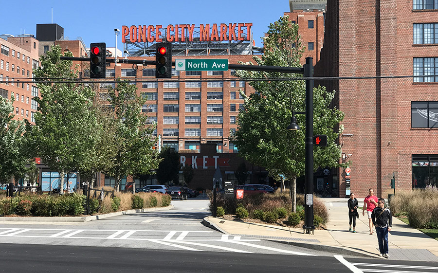
The City of Atlanta has become a pioneer in experimenting with these technologies with the North Avenue Smart Corridor—a model that could soon be replicated in other states. And the city has good reason to experiment: its traffic was ranked eighth in the world for congestion, and the average commuter spends nearly three days stuck in traffic each year!
Let’s take a closer look at the project and the technologies that it’s leveraging to improve traffic safety and efficiency.
Atlanta’s Living Lab & Public Demo
The City of Atlanta and Georgia Institute of Technology recently launched the North Avenue Smart Corridor in mid-September 2017 under the Renew Atlanta infrastructure improvement program.
The 2.3-mile corridor has higher-than-average crash rates and runs through the Georgia Institute of Technology’s campus and near many of the cities largest employers, with a MARTA metro station and 18 traffic intersections along the way.
The corridor will serve as a public demo with over 100 Internet of Things (IoT) sensors, adaptive signal timing systems, vehicle-to-infrastructure communications and re-striping can improve traffic safety and support future autonomous vehicles.
In addition to improving traffic flow and safety, researchers will be able to access valuable data to help better understand the connections between emissions, energy consumption, traffic congestion and public safety. The researchers can use this data to recommend adjustments and improve the corridor over time.
Connecting the Smart City
The City of Atlanta’s Smart Corridors use Applied Information’s Glance Smart Cities SupervisoryTM technology to power the 18 intersections that run through it.
[content_upgrade cu_id=”2399″]Download: Smart City Tech You Can Deploy Today[content_upgrade_button]Click Here[/content_upgrade_button][/content_upgrade]
The platform enables the city to manage all of their traffic and ITS assets within a single web-based application that makes it easy to visualize the data on Google Maps. For example, municipal users can use the app to see the routes that emergency vehicles are taking to respond to a call, identify average response times and look for ways to improve the routes.
Vehicle-to-Infrastructure
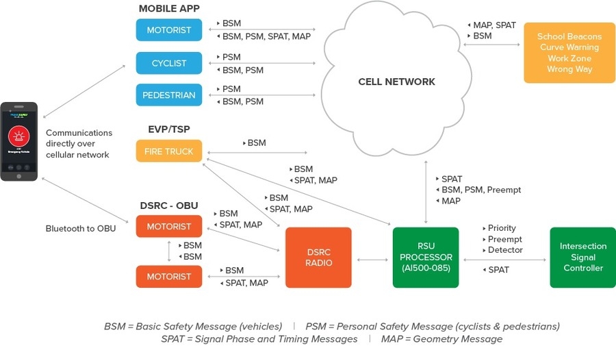
The City of Atlanta’s Smart Corridors will also use the Glance TravelSafelyTM app to connect smartphone users—both consumer and municipal—to the GlanceTM platform.
The connected vehicle technology interfaces with traffic signal controllers and sends information to motorists through dedicated short range radios (DSRC) and/or cellular communications. The DSRC signals can be read by connected vehicles, while the cellular communications can be sent directly to individual smartphones located in the target areas.
[bctt tweet=”TravelSafely provides audible warnings to consumers and helps muni vehicles get through traffic.” username=”AppInfoInc”]
For consumers, the TravelSafely app provides audible warnings for everything, from a light turning green to potentially dangerous road conditions to entering a school zone, all without interfering with users’ favorite mapping apps like Google Maps or Apple Maps. Pedestrians and cyclists can also use the app to receive alerts when they may be in imminent danger from approaching vehicles.
For municipal and emergency workers, the app can help ambulances or firetrucks get through traffic signals and prioritize bus and transit vehicles to reduce wait times. These vehicles can also see traffic signal timers to prepare to move in advance and maximize traffic efficiency, as well as access various other features to simplify their transportation.
Adaptive Signal Timing
The City of Atlanta’s adaptive signal timing technology leverages artificial intelligence, thermal imaging, and video cameras to respond in real-time to pedestrians and cyclists (without the need to press any buttons) while factoring in vehicle types, speeds and queues to maximize efficiency. These features could dramatically improve the corridor’s bike and pedestrian friendliness without sacrificing traffic lanes.
For example, cyclists don’t have to get off their bike to press a button and change the traffic signal, even if there are no vehicles next to them. Green lights can also be extended automatically if there’s a large traffic queue in one direction but not the other to help traffic move more efficiently.
In fact, the technology could play an important role in minimizing traffic congestion, which can improve the economy by reducing commutes and improve air quality by reducing emissions. This could be especially important as many cities struggle to meet emissions standards while still experiencing growing populations and numbers of vehicles on the road.
Ready-to-Use Technology
Applied Information partnered with Temple Inc. to supply connected vehicle technology, including the bus rapid transit priority, to the City of Atlanta’s second Smart Corridor on Campbellton Road. But these technologies are available right now to any municipalities that want to improve their traffic safety and efficiency.
[content_upgrade cu_id=”2399″]Download: Smart City Tech You Can Deploy Today[content_upgrade_button]Click Here[/content_upgrade_button][/content_upgrade]
Applied Information sells several smart city solutions that work alongside existing infrastructure, including the following:
- School Zone Flashing Beacons – Cities can easily view and control school beacon flashers and their schedules from anywhere rather than individually setting timers.
- Next Gen Priority and Preemption – Cellular, radio, and GPS technologies are combined to mitigate dead reckoning issues in low signal areas and quickly clear traffic at intersections.
- Smart Intersections – Easily monitor AC power, battery backup, cabinet flash, stop time, conflict monitor status, door switches, fan status, vehicle detectors and more.
- Parking Solutions – Add parking guidance and single-space parking sensors to enhance citywide parking solutions and make it easier for motorists to find a spot.
These solutions can be installed alongside existing traffic solutions to simplify the process, but municipalities may also want to consider upgrading to the GlanceTM platform, which greatly enhances functionality by offering a web-based interface for municipal workers to see and manage everything.
If you would like to learn more about these solutions, contact us today for a free consultation or any product literature.
[…] ten to fifteen percent by responding to traffic flow in real-time. Atlanta similarly launched its North Avenue Smart Corridor in mid-September 2017, which features over 100 Internet of Things (IoT) sensors, adaptive signal […]
[…] September 2017, the SmartATL team partnered with the Georgia Institute of Technology to launch the North Avenue Smart Corridor. With over 100 IoT sensors, adaptive signal timing, and V2X communication, the 2.3 mile corridor […]